
Santa Lucía topographic map
Interactive map
Click on the map to display elevation.
About this map
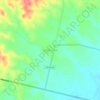
Name: Santa Lucía topographic map, elevation, terrain.
Location: Santa Lucía, Centro, Córdoba, RAP Caribe, Colombia (8.82538 -76.05778 8.86538 -76.01778)
Average elevation: 62 m
Minimum elevation: 35 m
Maximum elevation: 116 m
Other topographic maps
Click on a map to view its topography, its elevation and its terrain.
Parque Lineal Ronda del Sinú
Parque Lineal Ronda del Sinú, Centro, Córdoba, Colombia
Average elevation: 16 m