
Thank you for supporting this site ❤️
Make a donation
Make a donation
Ouled M'Barek topographic map
Click on the map to display elevation.
Thank you for supporting this site ❤️
Make a donation
Make a donation
About this map
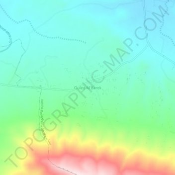
Name: Ouled M'Barek topographic map, elevation, terrain.
Location: Ouled M'Barek, Beïda Bordj, Ain Azal District, Setif, Algeria (35.78689 5.61137 35.82689 5.65137)
Average elevation: 1,044 m
Minimum elevation: 941 m
Maximum elevation: 1,312 m
Thank you for supporting this site ❤️
Make a donation
Make a donation
Other topographic maps
Click on a map to view its topography, its elevation and its terrain.