
Limerick City topographic map
Interactive map
Click on the map to display elevation.
About this map
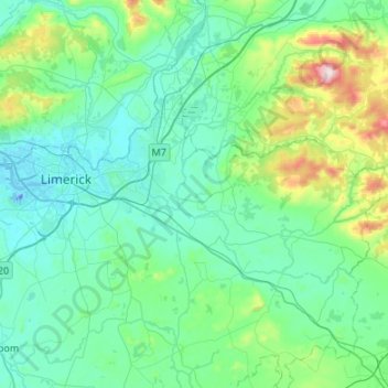
Name: Limerick City topographic map, elevation, terrain.
Location: Limerick City, County Limerick, Munster, Ireland (52.53981 -8.72616 52.75738 -8.18786)
Average elevation: 102 m
Minimum elevation: -26 m
Maximum elevation: 690 m
Other topographic maps
Click on a map to view its topography, its elevation and its terrain.
The Municipal District of Adare — Rathkeale
The Municipal District of Adare — Rathkeale, County Limerick, Munster, Ireland
Average elevation: 74 m
Adare
Ireland > County Limerick > The Municipal District of Adare — Rathkeale
Adare, The Municipal District of Adare — Rathkeale, County Limerick, Munster, Ireland
Average elevation: 12 m
Courtbrack
Ireland > County Limerick > Limerick
Courtbrack, Dock D, The Metropolitan District of Limerick City, Limerick, County Limerick, Munster, V94 VH4X, Ireland
Average elevation: 7 m
Galbally
Galbally, County Limerick, Munster, Ireland
Average elevation: 146 m
Strand
Ireland > County Limerick > The Municipal District of Newcastle West
Strand, Monagay, The Municipal District of Newcastle West, County Limerick, Munster, V42 AV66, Ireland
Average elevation: 170 m
Elton
Ireland > County Limerick > The Municipal District of Cappamore — Kilmallock
Elton, The Municipal District of Cappamore — Kilmallock, County Limerick, Munster, Ireland
Average elevation: 104 m
Ardroe
Ireland > County Limerick > The Municipal District of Cappamore — Kilmallock
Ardroe, Kilmurry, The Municipal District of Cappamore — Kilmallock, County Limerick, Munster, Ireland
Average elevation: 102 m
Balline
Ireland > County Limerick > The Municipal District of Cappamore — Kilmallock
Balline, Emlygrennan, The Municipal District of Cappamore — Kilmallock, County Limerick, Munster, Ireland
Average elevation: 109 m
Gooseberry Hill
Ireland > County Limerick > The Municipal District of Cappamore — Kilmallock
Gooseberry Hill, The Municipal District of Cappamore — Kilmallock, County Limerick, Munster, Ireland
Average elevation: 217 m
Lough Gur
Ireland > County Limerick > The Municipal District of Cappamore — Kilmallock
Lough Gur, Grange, The Municipal District of Cappamore — Kilmallock, County Limerick, Munster, Ireland
Average elevation: 84 m
Kilduff
Ireland > County Limerick > The Municipal District of Cappamore — Kilmallock
Kilduff, Grean, The Municipal District of Cappamore — Kilmallock, County Limerick, Munster, Ireland
Average elevation: 80 m
Ballynoe
Ireland > County Limerick > Limerick
Ballynoe, Ballycummin ED, The Metropolitan District of Limerick City, Limerick, County Limerick, Munster, Ireland
Average elevation: 13 m
Limerick
Ireland > County Limerick > Limerick
Limerick, The Metropolitan District of Limerick City, County Limerick, Munster, Ireland
Average elevation: 10 m
Dereen
Ireland > County Limerick > The Metropolitan District of Limerick City
Dereen, Castleconnell, The Metropolitan District of Limerick City, County Limerick, Munster, Ireland
Average elevation: 32 m
Abbeyfeale
Ireland > County Limerick > The Municipal District of Newcastle West > Abbeyfeale
Abbeyfeale, The Municipal District of Newcastle West, County Limerick, Munster, Ireland
Average elevation: 122 m
Milltown Bridge
Ireland > County Limerick > The Municipal District of Adare — Rathkeale
Milltown Bridge, Dromard, The Municipal District of Adare — Rathkeale, County Limerick, Munster, V94 HF80, Ireland
Average elevation: 29 m
Ballylanders
Ireland > County Limerick > The Municipal District of Cappamore — Kilmallock > Ballylanders
Ballylanders, The Municipal District of Cappamore — Kilmallock, County Limerick, Munster, Ireland
Average elevation: 163 m
Kildimo
Ireland > County Limerick > The Municipal District of Adare — Rathkeale
Kildimo, The Municipal District of Adare — Rathkeale, County Limerick, Munster, Ireland
Average elevation: 10 m
Bilboa
Ireland > County Limerick > The Municipal District of Cappamore — Kilmallock
Bilboa, Bilboa ED, The Municipal District of Cappamore — Kilmallock, County Limerick, Munster, Ireland
Average elevation: 88 m
Rathmore
Ireland > County Limerick > The Municipal District of Adare — Rathkeale
Rathmore, The Municipal District of Adare — Rathkeale, County Limerick, Munster, Ireland
Average elevation: 56 m
Marlbrook
Ireland > County Limerick > The Municipal District of Adare — Rathkeale
Marlbrook, Kilpeacon, The Municipal District of Adare — Rathkeale, County Limerick, Munster, Ireland
Average elevation: 35 m