
Thank you for supporting this site ❤️
Make a donation
Make a donation
Patirana topographic map
Click on the map to display elevation.
Thank you for supporting this site ❤️
Make a donation
Make a donation
About this map
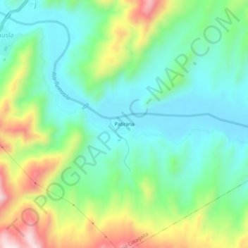
Name: Patirana topographic map, elevation, terrain.
Average elevation: 2,693 m
Minimum elevation: 2,551 m
Maximum elevation: 3,000 m
Thank you for supporting this site ❤️
Make a donation
Make a donation
Other topographic maps
Click on a map to view its topography, its elevation and its terrain.
Pampa Grande
Bolivia > Potosí > Provincia Nor Chichas > Municipio Cotagaita
Average elevation: 2,510 m