
Thank you for supporting this site ❤️
Make a donation
Make a donation
Murphytown topographic map
Click on the map to display elevation.
Thank you for supporting this site ❤️
Make a donation
Make a donation
About this map
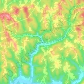
Name: Murphytown topographic map, elevation, terrain.
Location: Murphytown, Wood County, West Virginia, United States (39.21396 -81.46345 39.25396 -81.42345)
Average elevation: 241 m
Minimum elevation: 180 m
Maximum elevation: 308 m
Thank you for supporting this site ❤️
Make a donation
Make a donation
Other topographic maps
Click on a map to view its topography, its elevation and its terrain.