
Thank you for supporting this site ❤️
Make a donation
Make a donation
Buchholz topographic map
Click on the map to display elevation.
Thank you for supporting this site ❤️
Make a donation
Make a donation
About this map
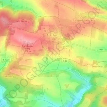
Name: Buchholz topographic map, elevation, terrain.
Average elevation: 301 m
Minimum elevation: 233 m
Maximum elevation: 350 m
Thank you for supporting this site ❤️
Make a donation
Make a donation
Other topographic maps
Click on a map to view its topography, its elevation and its terrain.
Thank you for supporting this site ❤️
Make a donation
Make a donation
Helme
Deutschland > Thüringen > Landkreis Nordhausen > Nordhausen > Sundhausen
Average elevation: 182 m