
Thank you for supporting this site ❤️
Make a donation
Make a donation
Margaret Roding topographic map
Click on the map to display elevation.
Thank you for supporting this site ❤️
Make a donation
Make a donation
About this map
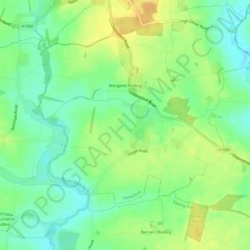
Name: Margaret Roding topographic map, elevation, terrain.
Location: Margaret Roding, Uttlesford, Essex, England, United Kingdom (51.76731 0.29640 51.79070 0.34829)
Average elevation: 65 m
Minimum elevation: 51 m
Maximum elevation: 81 m
Thank you for supporting this site ❤️
Make a donation
Make a donation
Other topographic maps
Click on a map to view its topography, its elevation and its terrain.