
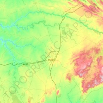
Trujillo topographic map
Interactive map
Click on the map to display elevation.
About this map
Name: Trujillo topographic map, elevation, terrain.
Location: Trujillo, Cáceres, Extremadura, 10200, Spanje (39.32240 -6.30515 39.66723 -5.73075)
Average elevation: 475 m
Minimum elevation: 241 m
Maximum elevation: 1,013 m
Trujillo heeft een bevolkingsaantal van 9.436 (1 januari 2016). De stad is gelegen op een hoogte van 564 meter boven de zeespiegel en heeft een oppervlakte van 650 km².
Other topographic maps
Click on a map to view its topography, its elevation and its terrain.
Bienvenida
Bienvenida, Badajoz, Extremadura, 06250, Spanje
Average elevation: 582 m
Fuente del Arco
Fuente del Arco, Badajoz, Extremadura, 06980, Spanje
Average elevation: 542 m
Alvao
Spanje > Extremadura > Descargamaría
Alvao, Descargamaría, Cáceres, Extremadura, 10865, Spanje
Average elevation: 574 m
Badajoz
Spanje > Extremadura > Tierra de Badajoz > Badajoz
Badajoz, Tierra de Badajoz, Badajoz, Extremadura, Spanje
Average elevation: 261 m
Guadalupe
Spanje > Extremadura > Guadalupe
Guadalupe, Las Villuercas, Cáceres, Extremadura, 10140, Spanje
Average elevation: 764 m
Alía
Spanje > Extremadura > Alía
Alía, Las Villuercas, Cáceres, Extremadura, Spanje
Average elevation: 643 m
Montánchez
Spanje > Extremadura > Montánchez
Montánchez, Cáceres, Extremadura, Spanje
Average elevation: 425 m
Badajoz
Spanje > Extremadura > Badajoz
Badajoz, Tierra de Badajoz, Badajoz, Extremadura, Spanje
Average elevation: 185 m
Parque Nacional de Monfragüe
Spanje > Extremadura > Torrejón el Rubio
Parque Nacional de Monfragüe, Calleja larga, Torrejón el Rubio, Cáceres, Extremadura, Spanje
Average elevation: 351 m