
Thank you for supporting this site ❤️
Make a donation
Make a donation
Melchingen topographic map
Click on the map to display elevation.
Thank you for supporting this site ❤️
Make a donation
Make a donation
About this map
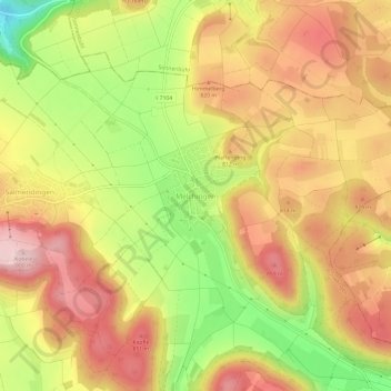
Name: Melchingen topographic map, elevation, terrain.
Average elevation: 776 m
Minimum elevation: 620 m
Maximum elevation: 892 m
Thank you for supporting this site ❤️
Make a donation
Make a donation
Other topographic maps
Click on a map to view its topography, its elevation and its terrain.
Stetten unter Holstein
Deutschland > Baden-Württemberg > Zollernalbkreis > Burladingen
Average elevation: 776 m
Thank you for supporting this site ❤️
Make a donation
Make a donation
72393
Deutschland > Baden-Württemberg > Zollernalbkreis > Burladingen > Ringingen
Average elevation: 785 m
Hausen im Killertal
Deutschland > Baden-Württemberg > Zollernalbkreis > Burladingen
Average elevation: 820 m