
Make a donation
Currituck County topographic map
Click on the map to display elevation.
Make a donation
About this map
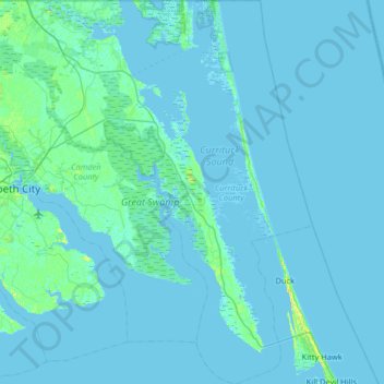
Name: Currituck County topographic map, elevation, terrain.
Location: Currituck County, North Carolina, United States (36.02884 -76.31331 36.55092 -75.70908)
Average elevation: 1 m
Minimum elevation: -4 m
Maximum elevation: 14 m
Make a donation
Other topographic maps
Click on a map to view its topography, its elevation and its terrain.
West Point on the Eno
United States > North Carolina > Durham County > Durham > Heritage Heights
Average elevation: 112 m
Mount Mitchell
United States > North Carolina > Yancey County
Mount Mitchell (Attakulla in Cherokee) is the highest peak of the Appalachian Mountains and the highest peak in mainland North America east of the Mississippi River. It is located near Burnsville in Yancey County, North Carolina in the Black Mountain subrange of the Appalachians about 19 miles (31 km)…
Average elevation: 1,743 m
Atlantic Coastal Plain
United States > North Carolina > Fayetteville
The province's average elevation is less than 900 meters above sea level and extends some 50 to 100 kilometers inland from the ocean. The coastal plain is normally wet, including many rivers, marsh, and swampland. It is composed primarily of sedimentary rock and unlithified sediments and is primarily used for…
Average elevation: 51 m