
Thank you for supporting this site ❤️
Make a donation
Make a donation
Jackson County topographic map
Click on the map to display elevation.
Thank you for supporting this site ❤️
Make a donation
Make a donation
About this map
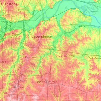
Name: Jackson County topographic map, elevation, terrain.
Location: Jackson County, Missouri, United States (38.83317 -94.60818 39.23728 -94.10476)
Average elevation: 268 m
Minimum elevation: 208 m
Maximum elevation: 338 m
Thank you for supporting this site ❤️
Make a donation
Make a donation
Other topographic maps
Click on a map to view its topography, its elevation and its terrain.
Taum Sauk Mountain
United States > Missouri > Iron County
Taum Sauk Mountain /ˈtɔːm ˈsɔːk/ in the Saint Francois Mountains is the highest natural point in the U.S. state of Missouri at 1,772 feet (540 m). The topography of Taum Sauk is that of an elongated ridge with a NNW-SSE orientation rather than a peak.
Average elevation: 466 m