
Thank you for supporting this site ❤️
Make a donation
Make a donation
Bouniague topographic map
Click on the map to display elevation.
Thank you for supporting this site ❤️
Make a donation
Make a donation
About this map
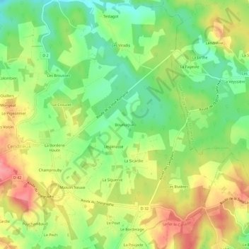
Name: Bouniague topographic map, elevation, terrain.
Average elevation: 214 m
Minimum elevation: 170 m
Maximum elevation: 264 m
Thank you for supporting this site ❤️
Make a donation
Make a donation
Other topographic maps
Click on a map to view its topography, its elevation and its terrain.
Sainte-Alvère
France > Nouvelle-Aquitaine > Dordogne > Val de Louyre et Caudeau
Average elevation: 192 m