
Make a donation
Jeju Island topographic map
Click on the map to display elevation.
Make a donation
Jeju Island
The climate of the highlands in the middle of the island where Hallasan is located is quite different from that of the rest of the island. As the altitude increases, the average temperature decreases and the climate becomes colder. The highlands of Jeju Island have the highest annual precipitation in Korea.
Make a donation
About this map
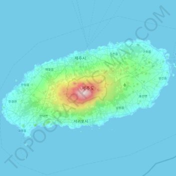
Name: Jeju Island topographic map, elevation, terrain.
Location: Jeju Island, Jeju, South Korea (33.19505 126.16064 33.56564 126.94701)
Average elevation: 98 m
Minimum elevation: -1 m
Maximum elevation: 1,923 m
Make a donation
Other topographic maps
Click on a map to view its topography, its elevation and its terrain.
Make a donation
Make a donation
Dokdo-ri
The Liancourt Rocks, known in Korea as Dokdo (Korean: 독도) and in Japan as Takeshima (Japanese: 竹島), are a group of islets in the Sea of Japan between the Korean Peninsula and the Japanese archipelago administered by South Korea. The Liancourt Rocks comprise two main islets and 35 smaller rocks; the…
Average elevation: 0 m
Make a donation
Make a donation
Make a donation
Make a donation
Make a donation
Make a donation
Make a donation
Make a donation
Make a donation
Make a donation
Make a donation
Make a donation
Make a donation
Make a donation
Make a donation
Make a donation
Make a donation
Make a donation
Make a donation
Turczaninow Hornbeam Tree at Chamseongdan Altar
South Korea > Ganghwa-gun > Incheon > Hwado-myeon
Average elevation: 155 m
Make a donation
Make a donation
Make a donation
Make a donation