
Make a donation
Daegu topographic map
Click on the map to display elevation.
Make a donation
About this map
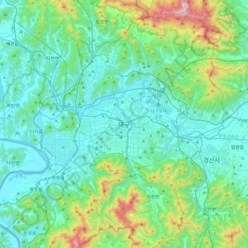
Name: Daegu topographic map, elevation, terrain.
Location: Daegu, 41939, South Korea (35.71130 128.44180 36.03130 128.76180)
Average elevation: 213 m
Minimum elevation: 5 m
Maximum elevation: 1,176 m
Make a donation
Other topographic maps
Click on a map to view its topography, its elevation and its terrain.
Jeju Island
The climate of the highlands in the middle of the island where Hallasan is located is quite different from that of the rest of the island. As the altitude increases, the average temperature decreases and the climate becomes colder. The highlands of Jeju Island have the highest annual precipitation in Korea.
Average elevation: 98 m
Make a donation
Make a donation
Jeju Island
The climate of the highlands in the middle of the island where Hallasan is located is quite different from those of the rest of the island. The higher the altitude, the lower the average temperature and the colder the climate. The highlands of Jeju Island have the highest annual precipitation in Korea.
Average elevation: 98 m
Seodaemun-gu
Seodaemun District incorporates residential areas and historical areas including Bongwon Temple, Sinchon Railway Station (the oldest train station in Seoul) and Seodaemun Prison History Hall. Also it has a historic culture site "Seodaemun Independence Park." This place located at Dongnimmun station, includes a…
Average elevation: 70 m
Make a donation
Make a donation
Make a donation
Jeju
The island is home to 660,000 people, but hosts 15,000,000 visitors per year. English is not widely spoken in Jeju, and as a matter of fact, "the local dialect is different enough from Korean that it is recognized as a distinct language." "Until recently, Chinese travelers accounted for 80% of foreign…
Average elevation: 28 m
Make a donation
Make a donation
Make a donation
Make a donation
Make a donation
Make a donation
Pyeongchang-gun
Pyeongchang (English: /ˌpjʌŋˈtʃɑːŋ/ pyung-CHAHNG, Korean: [pʰjʌŋtɕʰaŋ]; in full, Pyeongchang-gun [pʰjʌŋtɕʰaŋɡun]) is a county in the province of Gangwon-do, South Korea, located in the Taebaek Mountains region. It is home to several Buddhist temples, including Woljeongsa. It is about 180…
Average elevation: 658 m
Make a donation
Make a donation
Make a donation
South Chungcheong
At 845 metres, Mount Gyeryong is the most notable elevation. It is located in a national park which is noted for its unique rock features. Apart from the stone formations there are a number of old temples. These include Gwanchok-sa, a temple which is home to the largest stone Buddha in Korea. In 1978 the Taean…
Average elevation: 89 m
Make a donation
Pyeongtaek-si
With its low average elevation, Pyeongtaek has the warmest January average temperature in Gyeonggi Province at -4.5°C and the hottest average temperature in August at 26.4°C. The annual average precipitation is 1,100 millimeters with an average of 283.4 millimeters in July and 207.3 millimeters in August,…
Average elevation: 59 m
Make a donation
Make a donation
Make a donation
Jeju Island
The climate of the highlands in the middle of the island where Hallasan is located is quite different from that of the rest of the island. As the altitude increases, the average temperature decreases and the climate becomes colder. The highlands of Jeju Island have the highest annual precipitation in Korea.
Average elevation: 98 m
Yongsan-gu
Yongsan is located next to the Han River, with level ground in the west of the district which has been used for transportation (rail) and commercial use since the early 20th century. To the east and north in the land is steeper and rises towards Namsan which lies to the north. Namsan has an elevation of 243m…
Average elevation: 39 m
Seoraksan National Park
The reserve has an area of 163.6 square kilometres (63.2 sq mi) and includes many mountain peaks measuring over 1,200 metres above sea level, the tallest being Daecheongbong, at an altitude of 1,708 metres (5,604 ft). The ranges are composed largely of dissected granite and gneiss. The annual precipitation is…
Average elevation: 611 m
Make a donation
Anyang-si
The main river is Anyang River (one of the four main tributaries of the Han River in Seoul), which is 32.2 km (20.0 mi) long. It has a basin area of 275 km2 (106 sq mi), fed by 21 tributaries. The center of the overall elliptical basin topography is low and flat. The river runs through the center of Anyang and…
Average elevation: 126 m
Make a donation
Make a donation
Make a donation
Dong-gu
The city area is developed on a hill with an elevation of 30–40 m above sea level, and the reclaimed land on the north coast is formed as a seashore industrial complex, forming a part of the Incheon seashore industrial zone and connected to the Juan and Bupyeong industrial complexes. Although the population…
Average elevation: 15 m
Make a donation
Make a donation
Make a donation