
Thank you for supporting this site ❤️
Make a donation
Make a donation
Feldafing topographic map
Click on the map to display elevation.
Thank you for supporting this site ❤️
Make a donation
Make a donation
Feldafing
Feldafing ist eine Gemeinde im oberbayerischen Landkreis Starnberg. Diese wurde nach dem gleichnamigen Hauptort benannt, der auf einer Höhe um 650 m ü. NHN am Westufer des Starnberger Sees liegt.
Thank you for supporting this site ❤️
Make a donation
Make a donation
About this map
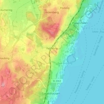
Name: Feldafing topographic map, elevation, terrain.
Location: Feldafing, Landkreis Starnberg, Bayern, 82340, Deutschland (47.91909 11.26121 47.97051 11.31040)
Average elevation: 633 m
Minimum elevation: 581 m
Maximum elevation: 720 m
Thank you for supporting this site ❤️
Make a donation
Make a donation
Other topographic maps
Click on a map to view its topography, its elevation and its terrain.