
Thank you for supporting this site ❤️
Make a donation
Make a donation
Kalay topographic map
Click on the map to display elevation.
Thank you for supporting this site ❤️
Make a donation
Make a donation
Kalay
Geographically, the distinctive feature of the town is that the Tropic of Cancer passes through it. This point has been marked by the milepost 55/56 near Kyansitgon village. Set in terrain that has an average elevation of 450 feet (140 m) above mean sea level, the town has a picturesque backdrop of the Laytha Hill in the east and the Chin Hills in the west.
Thank you for supporting this site ❤️
Make a donation
Make a donation
About this map
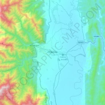
Name: Kalay topographic map, elevation, terrain.
Average elevation: 419 m
Minimum elevation: 96 m
Maximum elevation: 2,140 m
Thank you for supporting this site ❤️
Make a donation
Make a donation