
Thank you for supporting this site ❤️
Make a donation
Make a donation
La Croix topographic map
Click on the map to display elevation.
Thank you for supporting this site ❤️
Make a donation
Make a donation
About this map
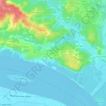
Name: La Croix topographic map, elevation, terrain.
Average elevation: 18 m
Minimum elevation: -4 m
Maximum elevation: 81 m
Thank you for supporting this site ❤️
Make a donation
Make a donation
Other topographic maps
Click on a map to view its topography, its elevation and its terrain.
Château de la Citadelle de Bourg sur Gironde
France > Nouvelle-Aquitaine > Gironde > Bourg > La Croix
Average elevation: 14 m