
Make a donation
Westbrookville topographic map
Click on the map to display elevation.
Make a donation
About this map
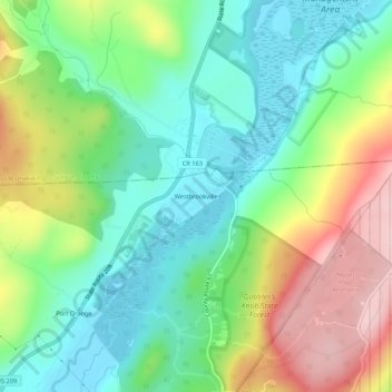
Name: Westbrookville topographic map, elevation, terrain.
Average elevation: 237 m
Minimum elevation: 145 m
Maximum elevation: 399 m
Make a donation
Other topographic maps
Click on a map to view its topography, its elevation and its terrain.
City of Newburgh
United States > New York > Orange County
Adjacent to Newburgh, the land rises at first sharply to a bluff, where many historic structures are located, offering sweeping views of the Hudson Highlands to the south; Mount Beacon to the east and the Newburgh—Beacon Bridge to the north; then more gradually to a relatively level western half. There are…
Average elevation: 32 m
West Point
United States > New York > Orange County > Village of Highland Falls
Average elevation: 200 m
Village of Walden
United States > New York > Orange County
The Wallkill passes through a small gorge between the two dams and loses approximately 60 feet (18 m) of elevation in the process. The surrounding topography in the village is, correspondingly, gentle rolling hills of this section of the Great Appalachian Valley between the higher rises of the Shawangunk…
Average elevation: 114 m
Make a donation
Village of Otisville
United States > New York > Orange County > Town of Mount Hope
Average elevation: 272 m
Village of Maybrook
United States > New York > Orange County > Town of Montgomery
The village is mostly flat, rising up to hills on its western side. The summit of one is its highest elevation, at 520 feet (160 m) above sea level. Maybrook's lowest point is a swampy, undeveloped area in iterns northeast corner, 360 feet (110 m) in elevation.
Average elevation: 121 m
Town of Cornwall
United States > New York > Orange County
This area of town is also mountainous and rugged, with the border descending along a northwesterly line to the narrow Woodbury Creek valley, where NY 32 and the New York State Thruway enter the town. At the valley's mouth, where Woodbury Creek drains into Moodna Creek, is the small hamlet of Mountainville,…
Average elevation: 182 m
Make a donation
Harriman State Park
United States > New York > Orange County > Town of Tuxedo
Average elevation: 219 m
Village of Greenwood Lake
United States > New York > Orange County > Town of Warwick
Average elevation: 272 m
Make a donation
Village of Harriman
United States > New York > Orange County > Town of Woodbury
Average elevation: 188 m
Make a donation
Make a donation
Make a donation
Town of Highlands
United States > New York > Orange County
Highlands is located at 41°21′36″N 074°00′30″W / 41.36000°N 74.00833°W / 41.36000; -74.00833 (41.3601108, -74.0084276) and its elevation is 1,017 feet (310 m). According to the 2020 U.S. census, the town has a total area of 33.46 square miles (86.66 km2), of which 30.40 square miles (78.74…
Average elevation: 192 m
Town of Montgomery
United States > New York > Orange County
The town's topography is generally level and low, except along parts of its eastern and western boundaries, reflecting the passage of the Wallkill River through it from north to west. There are large swamps in the south portion of town, some of them draining into the Otter Kill. Further north, the land becomes…
Average elevation: 128 m
Make a donation
Make a donation
Town of Montgomery
United States > New York > Orange County
The town's topography is generally level and low, except along parts of its eastern and western boundaries, reflecting the passage of the Wallkill River through it from north to west. There are large swamps in the south portion of town, some of them draining into the Otter Kill. Further north, the land becomes…
Average elevation: 128 m
Make a donation
Salisbury Mills
United States > New York > Orange County > Town of Cornwall > Salisbury Mills
Average elevation: 118 m
Village of Cornwall-on-Hudson
United States > New York > Orange County > Town of Cornwall
Average elevation: 124 m
Make a donation
Town of Highlands
United States > New York > Orange County
Highlands is located at 41°21′36″N 074°00′30″W / 41.36000°N 74.00833°W / 41.36000; -74.00833 (41.3601108, -74.0084276) and its elevation is 1,017 feet (310 m). According to the 2020 U.S. census, the town has a total area of 33.46 square miles (86.66 km2), of which 30.40 square miles (78.74…
Average elevation: 192 m
Make a donation
Make a donation
Village of Maybrook
United States > New York > Orange County > Town of Montgomery
The village is mostly flat, rising up to hills on its western side. The summit of one is its highest elevation, at 520 feet (160 m) above sea level. Maybrook's lowest point is a swampy, undeveloped area in iterns northeast corner, 360 feet (110 m) in elevation.
Average elevation: 121 m
West Point
United States > New York > Orange County > Village of Highland Falls
Average elevation: 200 m
Make a donation
Make a donation
Beaver Dam Lake
United States > New York > Orange County > Town of Blooming Grove
Average elevation: 115 m
Make a donation
Montgomery
United States > New York > Orange County > Montgomery
These lands in the west are the lowest-lying in the village. Much of its topography rises gently from the river, with little relief save the Academy Hill area on the east edge of downtown where the village hall is located, and a 455-foot (139 m) hill at the junction of Purple Martin Road and Cardinal Drive…
Average elevation: 118 m
Nathaniel Wetlands Inventory - R5UBH - 0.09 acres
United States > New York > Orange County
Average elevation: 138 m
Village of Walden
United States > New York > Orange County
The Wallkill passes through a small gorge between the two dams and loses approximately 60 feet (18 m) of elevation in the process. The surrounding topography in the village is, correspondingly, gentle rolling hills of this section of the Great Appalachian Valley between the higher rises of the Shawangunk…
Average elevation: 114 m
Make a donation