
Mönchengladbach topographic map
Interactive map
Click on the map to display elevation.
About this map
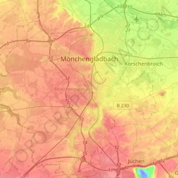
Name: Mönchengladbach topographic map, elevation, terrain.
Location: Mönchengladbach, Noordrijn-Westfalen, Duitsland (51.08578 6.29110 51.24789 6.53664)
Average elevation: 65 m
Minimum elevation: -34 m
Maximum elevation: 111 m
Other topographic maps
Click on a map to view its topography, its elevation and its terrain.
Asdonk
Duitsland > Noordrijn-Westfalen > Mönchengladbach > Donk
Asdonk, Donk, Bettrath-Hoven, Ost, Mönchengladbach, Noordrijn-Westfalen, 41066, Duitsland
Average elevation: 40 m
Nord
Duitsland > Noordrijn-Westfalen > Mönchengladbach
Nord, Mönchengladbach, Noordrijn-Westfalen, Duitsland
Average elevation: 68 m