
Thank you for supporting this site ❤️
Make a donation
Make a donation
Praia Verde topographic map
Click on the map to display elevation.
Thank you for supporting this site ❤️
Make a donation
Make a donation
About this map
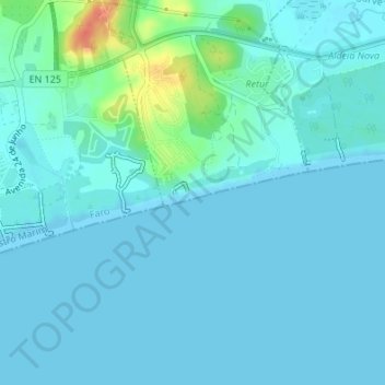
Name: Praia Verde topographic map, elevation, terrain.
Location: Praia Verde, Castro Marim, Faro, Portugal (37.17298 -7.48210 37.17493 -7.47576)
Average elevation: 7 m
Minimum elevation: 0 m
Maximum elevation: 49 m
Thank you for supporting this site ❤️
Make a donation
Make a donation
Other topographic maps
Click on a map to view its topography, its elevation and its terrain.