
Awanui topographic map
Interactive map
Click on the map to display elevation.
About this map
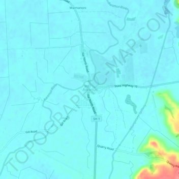
Name: Awanui topographic map, elevation, terrain.
Average elevation: 8 m
Minimum elevation: 0 m
Maximum elevation: 72 m
Other topographic maps
Click on a map to view its topography, its elevation and its terrain.
Aurere Beach
Nouvelle-Zélande > Northland > Far North District > Te Hiku Community
Aurere Beach, Te Hiku Community, Far North District, Northland, Nouvelle-Zélande
Average elevation: 14 m
Kaitaia
Nouvelle-Zélande > Northland > Far North District > Te Hiku Community
Kaitaia, Te Hiku Community, Far North District, Northland, 0441, Nouvelle-Zélande
Average elevation: 33 m