
Dunfanaghy topographic map
Interactive map
Click on the map to display elevation.
About this map
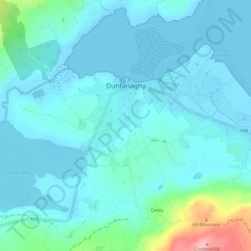
Name: Dunfanaghy topographic map, elevation, terrain.
Location: Dunfanaghy, County Donegal, F92 H0CY, Ireland (55.17342 -7.98103 55.18477 -7.95453)
Average elevation: 23 m
Minimum elevation: -1 m
Maximum elevation: 163 m
Other topographic maps
Click on a map to view its topography, its elevation and its terrain.
Clonmany
Clonmany, Inishowen Municipal District, County Donegal, F93 RRX6, Ireland
Average elevation: 47 m
Cruit Island
Cruit Island, Rutland ED, Glenties Municipal District, County Donegal, Ireland
Average elevation: 6 m
Murvagh Lower
Murvagh Lower, Ballintra ED, Donegal Municipal District, County Donegal, Ireland
Average elevation: 2 m
Lisfannan
Lisfannan, Burt ED, Inishowen Municipal District, County Donegal, Ireland
Average elevation: 48 m
Ballyliffin
Ballyliffin, Inishowen Municipal District, County Donegal, Ulster, Ireland
Average elevation: 76 m
Croaghross
Ireland > County Donegal > Letterkenny
Croaghross, Greenfort ED, Letterkenny, County Donegal, Ireland
Average elevation: 25 m
Crocknafeola
Crocknafeola, Killybegs ED, Donegal Municipal District, County Donegal, Ireland
Average elevation: 111 m
Carndonagh
Carndonagh, Inishowen Municipal District, County Donegal, Ireland
Average elevation: 54 m
Glenveagh National Park
Glenveagh National Park, Drumnalifferny Mountain, Dunlewy ED, Glenties Municipal District, County Donegal, Ulster, Ireland
Average elevation: 200 m
Greencastle
Greencastle, Inishowen Municipal District, County Donegal, Ireland
Average elevation: 46 m
Rosapenna
Ireland > County Donegal > Letterkenny
Rosapenna, Rosguill ED, Letterkenny, County Donegal, Ireland
Average elevation: 11 m
Corkey
Ireland > County Donegal > Letterkenny
Corkey, Kincraigy ED, Letterkenny, County Donegal, Ireland
Average elevation: 36 m
Donegal
Ireland > County Donegal > Donegal
Donegal, Donegal Municipal District, County Donegal, F94 P028, Ireland
Average elevation: 48 m
Ards Big
Ireland > County Donegal > Letterkenny
Ards Big, Rathmelton ED, Letterkenny, County Donegal, Ulster, Ireland
Average elevation: 62 m
Glenties
Glenties, Glenties ED, Glenties Municipal District, County Donegal, Ulster, F94 KX93, Ireland
Average elevation: 67 m
Alt Upper
Alt Upper, Urney West ED, Lifford-Stranorlar Municipal District, County Donegal, Ulster, Ireland
Average elevation: 142 m
Egglybane
Egglybane, Cloghard ED, Lifford-Stranorlar Municipal District, County Donegal, Ulster, Ireland
Average elevation: 141 m
Carrowkeel
Carrowkeel, County Donegal, Ulster, F92 PP6R, Ireland
Average elevation: 50 m
Drumcarbit
Drumcarbit, Malin ED, Inishowen Municipal District, County Donegal, Ulster, Ireland
Average elevation: 71 m
Cashel
Cashel, Donegal Municipal District, County Donegal, Ireland
Average elevation: 108 m
Maum
Maum, Glenties Municipal District, County Donegal, Ulster, Ireland
Average elevation: 179 m
Raphoe
Raphoe, Lifford-Stranorlar Municipal District, County Donegal, Ulster, Ireland
Average elevation: 87 m
Glengesh
Glengesh, Glengesh ED, Glenties Municipal District, County Donegal, Ireland
Average elevation: 217 m
Malin Head
Malin Head, Ardmalin ED, Inishowen Municipal District, County Donegal, Ireland
Average elevation: 4 m
Gortlee
Ireland > County Donegal > Letterkenny
Gortlee, Letterkenny Rural ED, Letterkenny, County Donegal, Ulster, Ireland
Average elevation: 34 m
Burt
Burt, Inishowen Municipal District, County Donegal, Ulster, Ireland
Average elevation: 87 m
Sheskinarone
Sheskinarone, Dunglow ED, Glenties Municipal District, County Donegal, Ireland
Average elevation: 43 m
Dunfanaghy
Dunfanaghy, Dunfanaghy Electoral Division, Glenties Municipal District, County Donegal, Ulster, F92 H0CY, Ireland
Average elevation: 21 m
Donegal Municipal District
Donegal Municipal District, County Donegal, Ulster, Ireland
Average elevation: 120 m
Inishowen Municipal District
Inishowen Municipal District, County Donegal, Ireland
Average elevation: 59 m
Carndonagh
Ireland > County Donegal > Carndonagh
Carndonagh, Inishowen Municipal District, County Donegal, F93 XD74, Ireland
Average elevation: 78 m
Oort
Oort, Gleneely ED, Inishowen Municipal District, County Donegal, Ireland
Average elevation: 86 m
Kilmacrennan
Ireland > County Donegal > Kilmacrennan
Kilmacrennan, County Donegal, Ireland
Average elevation: 63 m
Mamore Gap
Mamore Gap, Urris Hills Trail, Dunaff ED, Inishowen Municipal District, County Donegal, Ireland
Average elevation: 192 m
Letterkenny
Letterkenny, County Donegal, Ulster, Ireland
Average elevation: 92 m
Stroove
Ireland > County Donegal > Stroove
Stroove, Greencastle ED, Inishowen Municipal District, County Donegal, Ireland
Average elevation: 56 m
Diamond
Diamond, Knock ED, Lifford-Stranorlar Municipal District, County Donegal, F93 Y27K, Ireland
Average elevation: 142 m
Annagry
Ireland > County Donegal > Annagry
Annagry, Glenties Municipal District, County Donegal, Ireland
Average elevation: 32 m
Moyle
Ireland > County Donegal > Letterkenny
Moyle, Ballyarr ED, Letterkenny, County Donegal, Ireland
Average elevation: 55 m
Slieve League
Slieve League, Donegal Municipal District, County Donegal, Ireland
Average elevation: 233 m
Errigal
Errigal, Glenties Municipal District, County Donegal, Ireland
Average elevation: 295 m
Gweedore
Gweedore, Glenties Municipal District, County Donegal, Ireland
Average elevation: 131 m
Dunfanaghy
Ireland > County Donegal > Dunfanaghy
Dunfanaghy, Glenties Municipal District, County Donegal, F92 H0CY, Ireland
Average elevation: 45 m
Aghadowey
Aghadowey, Ballintra ED, Donegal Municipal District, County Donegal, Ireland
Average elevation: 101 m
Lough Eske
Lough Eske, Lough Eask ED, Donegal Municipal District, County Donegal, Ireland
Average elevation: 68 m