
Anergui topographic map
Interactive map
Click on the map to display elevation.
About this map
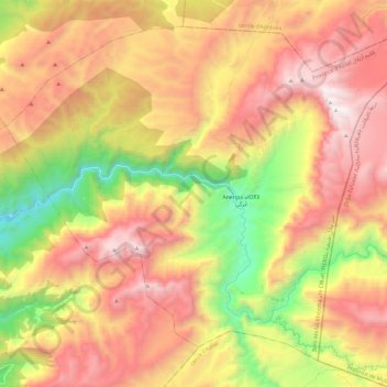
Name: Anergui topographic map, elevation, terrain.
Average elevation: 2,296 m
Minimum elevation: 1,265 m
Maximum elevation: 3,232 m
Other topographic maps
Click on a map to view its topography, its elevation and its terrain.
Ait Mazigh
Maroc > cercle d'Ouaouizeght > Ait Mazigh
Ait Mazigh, caïdat de Tilougguite, cercle d'Ouaouizeght, Province d'Azilal, Béni Mellal-Khénifra, Maroc
Average elevation: 1,518 m