Geolocate

Chiclayo topographic map

Interactive map

Click on the map to display elevation.

About this map

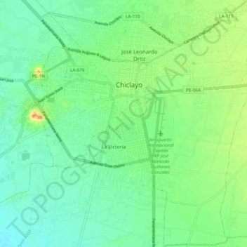
Name: Chiclayo topographic map, elevation, terrain.

Location: Chiclayo, Province of Chiclayo, Lambayeque, Peru (-6.83260 -79.87229 -6.73985 -79.78012)

Average elevation: 28 m

Minimum elevation: 13 m

Maximum elevation: 61 m

Other topographic maps

Click on a map to view its topography, its elevation and its terrain.

Mayascón

Peru > Lambayeque

Average elevation: 402 m

Los Jagueyes de Mayascón

Peru > Lambayeque > Pítipo

Average elevation: 555 m

C

Peru > Lambayeque > Chiclayo

Average elevation: 24 m

Morrope

Peru > Lambayeque > Mórrope

Average elevation: 19 m

Puerto Etén

Peru > Lambayeque > Etén Puerto > Puerto Etén

Average elevation: 11 m

Hacienda Janque

Peru > Lambayeque > Incahuasi > Hacienda Janque

Average elevation: 2,247 m

Chiclayo

Peru > Lambayeque > Chiclayo

Average elevation: 39 m