
Thank you for supporting this site ❤️
Make a donation
Make a donation
Kvilda topographic map
Click on the map to display elevation.
Thank you for supporting this site ❤️
Make a donation
Make a donation
Kvilda
Kvilda (German: Außergefild) is a municipality and village in Prachatice District in the South Bohemian Region of the Czech Republic. It has about 100 inhabitants. At an altitude of 1,065 metres (3,494 ft), it is the highest municipality in the Czech Republic. It is also one of the coldest places in the country.
Thank you for supporting this site ❤️
Make a donation
Make a donation
About this map
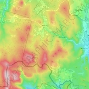
Name: Kvilda topographic map, elevation, terrain.
Average elevation: 1,095 m
Minimum elevation: 882 m
Maximum elevation: 1,376 m
Thank you for supporting this site ❤️
Make a donation
Make a donation
Other topographic maps
Click on a map to view its topography, its elevation and its terrain.