
Thank you for supporting this site ❤️
Make a donation
Make a donation
Bourdeau topographic map
Click on the map to display elevation.
Thank you for supporting this site ❤️
Make a donation
Make a donation
About this map
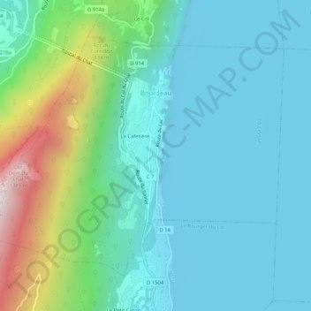
Name: Bourdeau topographic map, elevation, terrain.
Average elevation: 464 m
Minimum elevation: 223 m
Maximum elevation: 1,384 m
Thank you for supporting this site ❤️
Make a donation
Make a donation
Other topographic maps
Click on a map to view its topography, its elevation and its terrain.
Val Thorens
Frankreich > Auvergne-Rhone-Alpen > Savoyen
Val Thorens ist ein Wintersportort in der französischen Region Auvergne-Rhône-Alpes. Politisch gehört Val Thorens zu Saint-Martin-de-Belleville im Département Savoie. Er liegt auf 2300 m Höhe und ist somit der höchstgelegene Wintersportort in Europa.
Average elevation: 2,516 m