
Thank you for supporting this site ❤️
Make a donation
Make a donation
Langenordnach topographic map
Click on the map to display elevation.
Thank you for supporting this site ❤️
Make a donation
Make a donation
About this map
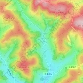
Name: Langenordnach topographic map, elevation, terrain.
Average elevation: 974 m
Minimum elevation: 843 m
Maximum elevation: 1,139 m
Thank you for supporting this site ❤️
Make a donation
Make a donation
Other topographic maps
Click on a map to view its topography, its elevation and its terrain.
Titisee
Deutschland > Baden-Württemberg > Landkreis Breisgau-Hochschwarzwald > Titisee-Neustadt > Titisee
Der Ortsteil Titisee von Titisee-Neustadt liegt am Nordufer des Titisees, im Osten des Feldbergs im Schwarzwald in 780 bis 1190 Meter Höhe. Der Ortsteil Neustadt befindet sich fünf Kilometer östlich davon. Die Stadt liegt an einem kleinen Fluss, der als Seebach vom Bärental kommend den Titisee speist, als…
Average elevation: 917 m