
Pritzwalk topographic map
Interactive map
Click on the map to display elevation.
About this map
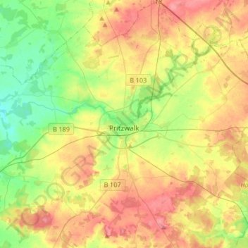
Name: Pritzwalk topographic map, elevation, terrain.
Location: Pritzwalk, Prignitz, Brandenburg, 16928, Duitsland (53.07251 12.08277 53.23080 12.33209)
Average elevation: 81 m
Minimum elevation: 42 m
Maximum elevation: 127 m
Other topographic maps
Click on a map to view its topography, its elevation and its terrain.
Helle
Duitsland > Brandenburg > Prignitz > Groß Pankow (Prignitz)
Helle, Groß Pankow (Prignitz), Prignitz, Brandenburg, Duitsland
Average elevation: 55 m