
Кара-Кулжа topographic map
Interactive map
Click on the map to display elevation.
About this map
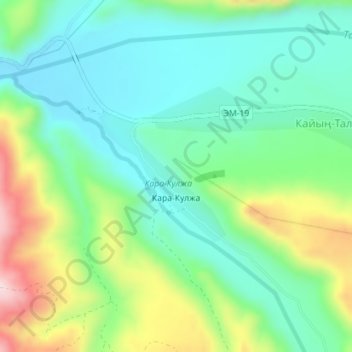
Name: Кара-Кулжа topographic map, elevation, terrain.
Location: Кара-Кулжа, Кара-Кульджинский район, Ошская область, Киргизия (40.29927 74.24020 40.30935 74.25299)
Average elevation: 2,210 m
Minimum elevation: 2,110 m
Maximum elevation: 2,432 m
Other topographic maps
Click on a map to view its topography, its elevation and its terrain.
Кара-Кульджа
Киргизия > Ошская область > Кара-Кульджинский район
Кара-Кульджа, Кара-Кульджинский район, Ошская область, Киргизия
Average elevation: 1,443 m