
Thank you for supporting this site ❤️
Make a donation
Make a donation
Saalthal-Alter topographic map
Click on the map to display elevation.
Thank you for supporting this site ❤️
Make a donation
Make a donation
About this map
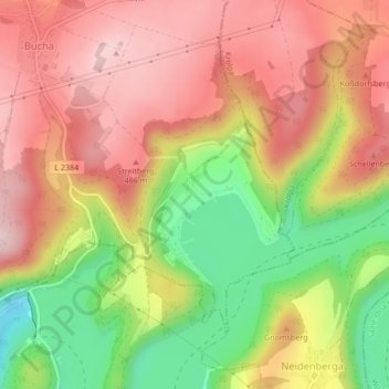
Name: Saalthal-Alter topographic map, elevation, terrain.
Average elevation: 398 m
Minimum elevation: 243 m
Maximum elevation: 512 m
Thank you for supporting this site ❤️
Make a donation
Make a donation
Other topographic maps
Click on a map to view its topography, its elevation and its terrain.
07333
Deutschland > Thüringen > Landkreis Saalfeld-Rudolstadt > Unterwellenborn
Average elevation: 304 m