
Southlawn topographic map
Interactive map
Click on the map to display elevation.
About this map
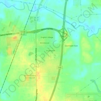
Name: Southlawn topographic map, elevation, terrain.
Average elevation: 57 m
Minimum elevation: 45 m
Maximum elevation: 73 m
Other topographic maps
Click on a map to view its topography, its elevation and its terrain.
Mountain View Estates
United States > Alabama > Montgomery County > Montgomery
Mountain View Estates, Montgomery, Montgomery County, Alabama, 36109, United States
Average elevation: 80 m
Carriage Hills
United States > Alabama > Montgomery County > Montgomery
Carriage Hills, Montgomery, Montgomery County, Alabama, 36116, United States
Average elevation: 75 m
Johnstown East
United States > Alabama > Montgomery County > Montgomery
Johnstown East, Montgomery, Montgomery County, Alabama, 36109, United States
Average elevation: 73 m
College Grove
United States > Alabama > Montgomery County > Montgomery
College Grove, Montgomery, Montgomery County, Alabama, 36109, United States
Average elevation: 76 m
Bellwood Plantation
United States > Alabama > Montgomery County > Montgomery > Bellwood Plantation
Bellwood Plantation, Montgomery, Montgomery County, Alabama, 36123, United States
Average elevation: 81 m
Mayfair
United States > Alabama > Montgomery County > Montgomery > Mayfair
Mayfair, Montgomery, Montgomery County, Alabama, 36109, United States
Average elevation: 84 m
Regency Forest
United States > Alabama > Montgomery County > Montgomery > Regency Forest
Regency Forest, Montgomery, Montgomery County, Alabama, 36116, United States
Average elevation: 67 m
Sunshine Village
United States > Alabama > Montgomery County > Montgomery > Sunshine Village
Sunshine Village, Montgomery, Montgomery County, Alabama, 36119, United States
Average elevation: 65 m