
Thank you for supporting this site ❤️
Make a donation
Make a donation
Vista topographic map
Click on the map to display elevation.
Thank you for supporting this site ❤️
Make a donation
Make a donation
About this map
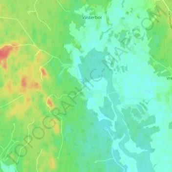
Name: Vista topographic map, elevation, terrain.
Location: Vista, Sandvikens kommun, Gävleborg County, Sweden (60.30960 16.72710 60.34960 16.76710)
Average elevation: 68 m
Minimum elevation: 53 m
Maximum elevation: 100 m
Thank you for supporting this site ❤️
Make a donation
Make a donation
Other topographic maps
Click on a map to view its topography, its elevation and its terrain.