
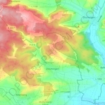
Zöschingen topographic map
Interactive map
Click on the map to display elevation.
About this map
Name: Zöschingen topographic map, elevation, terrain.
Average elevation: 524 m
Minimum elevation: 453 m
Maximum elevation: 616 m
Gut 500 m nördlich des Ortskerns von Zöschingen befindet sich der Zigeunerfelsen, eine angewitterte Felskuppe. Das geschützte Naturdenkmal (Geotopnummer 773R001) misst etwa 20 m in der Länge, 12 m in der Breite und erreicht eine Höhe von etwa 8 m. Es handelt sich um Erosionsreste von Malmkalken, Riestrümmermassen als Auswurfmaterial infolge des Meteoritenimpakts im Nördlinger Ries.
Other topographic maps
Click on a map to view its topography, its elevation and its terrain.
Leitenhof
Deutschland > Bayern > Landkreis Dillingen an der Donau > Bissingen
Leitenhof, Bissingen, Landkreis Dillingen an der Donau, Bayern, 86657, Deutschland
Average elevation: 499 m
Rischgau
Deutschland > Bayern > Landkreis Dillingen an der Donau
Rischgau, Villenbach, Wertingen, Landkreis Dillingen an der Donau, Bayern, 86450, Deutschland
Average elevation: 461 m