
Thank you for supporting this site ❤️
Make a donation
Make a donation
Ottweiler topographic map
Click on the map to display elevation.
Thank you for supporting this site ❤️
Make a donation
Make a donation
About this map
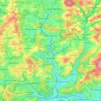
Name: Ottweiler topographic map, elevation, terrain.
Location: Ottweiler, Landkreis Neunkirchen, Saarland, 66564, Germany (49.38435 7.09076 49.44109 7.29285)
Average elevation: 329 m
Minimum elevation: 236 m
Maximum elevation: 513 m
Thank you for supporting this site ❤️
Make a donation
Make a donation