
Thank you for supporting this site ❤️
Make a donation
Make a donation
Braythorn topographic map
Click on the map to display elevation.
Thank you for supporting this site ❤️
Make a donation
Make a donation
About this map
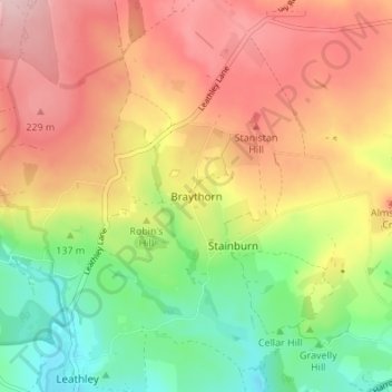
Name: Braythorn topographic map, elevation, terrain.
Average elevation: 156 m
Minimum elevation: 55 m
Maximum elevation: 252 m
Thank you for supporting this site ❤️
Make a donation
Make a donation
Other topographic maps
Click on a map to view its topography, its elevation and its terrain.
Dent Crag Ridge
United Kingdom > England > North Yorkshire > Harrogate > Dacre
Average elevation: 301 m
Kirkby Malzeard
United Kingdom > England > North Yorkshire > Harrogate > Kirkby Malzeard
Average elevation: 152 m
Thank you for supporting this site ❤️
Make a donation
Make a donation
Marston Moor
United Kingdom > England > North Yorkshire > Harrogate > Long Marston
Average elevation: 24 m