
Thank you for supporting this site ❤️
Make a donation
Make a donation
Sasak topographic map
Click on the map to display elevation.
Thank you for supporting this site ❤️
Make a donation
Make a donation
About this map
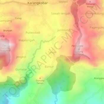
Name: Sasak topographic map, elevation, terrain.
Location: Sasak, Banjarnegara, Central Java, Java, Indonesia (-7.31034 109.72605 -7.27034 109.76605)
Average elevation: 950 m
Minimum elevation: 558 m
Maximum elevation: 1,286 m
Thank you for supporting this site ❤️
Make a donation
Make a donation
Other topographic maps
Click on a map to view its topography, its elevation and its terrain.