
Thank you for supporting this site ❤️
Make a donation
Make a donation
Cumbre de Chirgua topographic map
Click on the map to display elevation.
Thank you for supporting this site ❤️
Make a donation
Make a donation
About this map
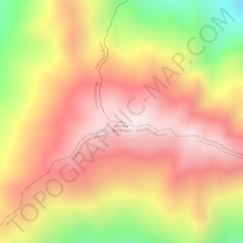
Name: Cumbre de Chirgua topographic map, elevation, terrain.
Average elevation: 1,520 m
Minimum elevation: 1,116 m
Maximum elevation: 1,753 m
Thank you for supporting this site ❤️
Make a donation
Make a donation
Other topographic maps
Click on a map to view its topography, its elevation and its terrain.
Parroquia Juan José Flores
Venezuela > Estado Carabobo > Municipio Puerto Cabello
Average elevation: 85 m
Thank you for supporting this site ❤️
Make a donation
Make a donation
Tejerías
Venezuela > Estado Carabobo > Municipio Puerto Cabello > Puerto Cabello
Average elevation: 44 m