
Übach-Palenberg topographic map
Interactive map
Click on the map to display elevation.
About this map
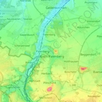
Name: Übach-Palenberg topographic map, elevation, terrain.
Average elevation: 116 m
Minimum elevation: 68 m
Maximum elevation: 230 m
Other topographic maps
Click on a map to view its topography, its elevation and its terrain.
Werlo
Allemagne > Rhénanie-du-Nord-Westphalie > Kreis Heinsberg > Heinsberg > Karken
Werlo, Karken, Heinsberg, Kreis Heinsberg, Rhénanie-du-Nord-Westphalie, 52525, Allemagne
Average elevation: 37 m
Selfkant
Allemagne > Rhénanie-du-Nord-Westphalie > Kreis Heinsberg
Selfkant, Kreis Heinsberg, Rhénanie-du-Nord-Westphalie, Allemagne
Average elevation: 55 m