
Make a donation
Maria Anzbach topographic map
Click on the map to display elevation.
Make a donation
About this map
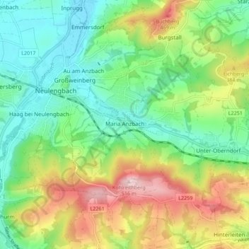
Name: Maria Anzbach topographic map, elevation, terrain.
Average elevation: 319 m
Minimum elevation: 212 m
Maximum elevation: 511 m
Make a donation
Other topographic maps
Click on a map to view its topography, its elevation and its terrain.
Make a donation
Am Hagen
Österreich > Niederösterreich > Bezirk St. Pölten > Pressbaum > Rekawinkel
Average elevation: 388 m
Sankt Andrä an der Traisen
Österreich > Niederösterreich > Bezirk St. Pölten > Herzogenburg
Average elevation: 232 m
Make a donation
Karlstetten
Österreich > Niederösterreich > Bezirk St. Pölten > Gemeinde Karlstetten
Average elevation: 382 m
Eitzendorf
Österreich > Niederösterreich > Bezirk St. Pölten > Gemeinde Obritzberg-Rust > Obritzberg
Average elevation: 324 m
Roppersberg
Österreich > Niederösterreich > Bezirk St. Pölten > Gemeinde Wolfsgraben
Average elevation: 395 m
Make a donation
Oberndorf in der Ebene
Österreich > Niederösterreich > Bezirk St. Pölten > Gemeinde Herzogenburg
Average elevation: 255 m
Wilhelmshöhe
Österreich > Niederösterreich > Bezirk St. Pölten > Gemeinde Tullnerbach
Average elevation: 391 m
Oberkühberg
Österreich > Niederösterreich > Bezirk St. Pölten > Neustift-Innermanzing
Average elevation: 424 m
Pyrat
Österreich > Niederösterreich > Bezirk St. Pölten > Gemeinde Brand-Laaben
Average elevation: 456 m
Make a donation
Kirchberg an der Pielach
Österreich > Niederösterreich > Bezirk St. Pölten > Gemeinde Kirchberg an der Pielach
Average elevation: 480 m
Walpersdorf
Österreich > Niederösterreich > Bezirk St. Pölten > Gemeinde Inzersdorf-Getzersdorf
Average elevation: 274 m
Laubenbachgegend
Österreich > Niederösterreich > Bezirk St. Pölten > Gemeinde Frankenfels
Average elevation: 688 m
Make a donation
Süßfeld
Österreich > Niederösterreich > Bezirk St. Pölten > Gemeinde Purkersdorf
Average elevation: 336 m
Make a donation
Kirchberggegend
Österreich > Niederösterreich > Bezirk St. Pölten > Gemeinde Kirchberg an der Pielach > Marbach
Average elevation: 554 m
Wimmersdorf
Österreich > Niederösterreich > Bezirk St. Pölten > Gemeinde Asperhofen
Average elevation: 273 m
Mitterfeld
Österreich > Niederösterreich > Bezirk St. Pölten > Kasten bei Böheimkirchen
Average elevation: 341 m