
Thank you for supporting this site ❤️
Make a donation
Make a donation
Schuylkill River topographic map
Click on the map to display elevation.
Thank you for supporting this site ❤️
Make a donation
Make a donation
About this map
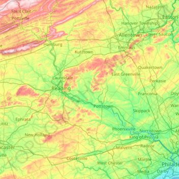
Name: Schuylkill River topographic map, elevation, terrain.
Average elevation: 157 m
Minimum elevation: -2 m
Maximum elevation: 540 m
Thank you for supporting this site ❤️
Make a donation
Make a donation
Other topographic maps
Click on a map to view its topography, its elevation and its terrain.
Gettysburg National Military Park
United States of America > Pennsylvania > Gettysburg
Average elevation: 166 m