
Thank you for supporting this site ❤️
Make a donation
Make a donation
Welda topographic map
Click on the map to display elevation.
Thank you for supporting this site ❤️
Make a donation
Make a donation
About this map
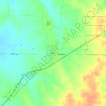
Name: Welda topographic map, elevation, terrain.
Location: Welda, Anderson County, Kansas, 66091, United States (38.14964 -95.31483 38.18964 -95.27483)
Average elevation: 339 m
Minimum elevation: 321 m
Maximum elevation: 361 m
Thank you for supporting this site ❤️
Make a donation
Make a donation
Other topographic maps
Click on a map to view its topography, its elevation and its terrain.