
Make a donation
Rockleigh topographic map
Click on the map to display elevation.
Make a donation
About this map
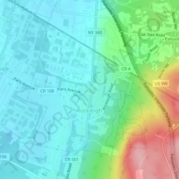
Name: Rockleigh topographic map, elevation, terrain.
Location: Rockleigh, Bergen County, New Jersey, United States (40.99360 -73.94284 41.01338 -73.92204)
Average elevation: 43 m
Minimum elevation: 6 m
Maximum elevation: 151 m
Make a donation
Other topographic maps
Click on a map to view its topography, its elevation and its terrain.
Make a donation
Make a donation
New Bridge
United States > New Jersey > Bergen County > New Milford > New Bridge
Average elevation: 19 m
Wallington
United States > New Jersey > Bergen County > Wallington > Wallington
Average elevation: 23 m
Make a donation
Warren Point
United States > New Jersey > Bergen County > Fair Lawn > Warren Point
Average elevation: 22 m
Ridgefield
United States > New Jersey > Bergen County > Ridgefield > Ridgefield
Average elevation: 24 m
River Edge
United States > New Jersey > Bergen County > River Edge > River Edge
Average elevation: 21 m
Make a donation
Make a donation