
Hohegeiß topographic map
Interactive map
Click on the map to display elevation.
About this map
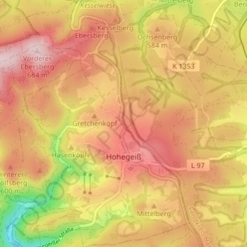
Name: Hohegeiß topographic map, elevation, terrain.
Average elevation: 568 m
Minimum elevation: 394 m
Maximum elevation: 679 m
Other topographic maps
Click on a map to view its topography, its elevation and its terrain.
Sankt Andreasberg
Deutschland > Niedersachsen > Landkreis Goslar > Braunlage
Sankt Andreasberg, Braunlage, Landkreis Goslar, Niedersachsen, Deutschland
Average elevation: 648 m
Jordanshöhe
Deutschland > Niedersachsen > Landkreis Goslar > Braunlage
Jordanshöhe, Braunlage, Landkreis Goslar, Niedersachsen, 37444, Deutschland
Average elevation: 672 m
Wurmberg
Deutschland > Niedersachsen > Landkreis Goslar > Braunlage
Wurmberg, Braunlage, Landkreis Goslar, Niedersachsen, 38879, Deutschland
Average elevation: 766 m
Waldmühle
Deutschland > Niedersachsen > Landkreis Goslar > Braunlage > Waldmühle
Waldmühle, Braunlage, Landkreis Goslar, Niedersachsen, 38700, Deutschland
Average elevation: 588 m
Silberhütte
Deutschland > Niedersachsen > Landkreis Goslar > Braunlage > Sankt Andreasberg > Silberhütte
Silberhütte, Sankt Andreasberg, Braunlage, Landkreis Goslar, Niedersachsen, 37444, Deutschland
Average elevation: 543 m