
Make a donation
Schmole topographic map
Click on the map to display elevation.
Make a donation
About this map
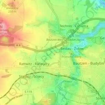
Name: Schmole topographic map, elevation, terrain.
Location: Schmole, Westvorstadt, Bautzen, Sachsen, 02625, Deutschland (51.16540 14.38572 51.20540 14.42572)
Average elevation: 212 m
Minimum elevation: 164 m
Maximum elevation: 268 m
Make a donation
Other topographic maps
Click on a map to view its topography, its elevation and its terrain.
Kleinwelka
Deutschland > Sachsen > Bautzen > Bautzen
Eine wichtige Rolle spielte ab 1778 das Internat für Kinder von Missionaren (Knaben- und Mädchenanstalt). Bis zu 140 und insgesamt über 2.000 Missionskinder kamen ab sechs Jahren über mehrere Jahre zur schulischen Ausbildung aus Labrador, Suriname, Tansania und Natal nach Kleinwelka und wechselten in…
Average elevation: 205 m
Salzenforst
Deutschland > Sachsen > Bautzen > Bautzen
Der Ort befindet sich etwa vier Kilometer nordwestlich des Bautzener Stadtzentrums am Nordwesthang des Chorberges (266 m), der die höchste Erhebung Bautzens und der näheren Umgebung darstellt. Hier wurde 1865 eine Vermessungssäule der Königlich-Sächsischen Triangulation errichtet. Der Ort selbst liegt…
Average elevation: 232 m
Make a donation
Niederkaina
Deutschland > Sachsen > Bautzen > Bautzen > Niederkaina
Niederkaina befindet sich im östlichen Stadtgebiet auf 165 m ü. NN am Albrechtsbach gelegen. Basankwitz befindet sich wenige hundert Meter östlich von Niederkaina flussabwärts an der Bundesautobahn 4 und circa 1,5 km (süd)westlich von Kreckwitz und den Kreckwitzer Höhen. Die Ortschaft war bis 1936 eine…
Average elevation: 174 m