
Espot topographic map
Interactive map
Click on the map to display elevation.
About this map
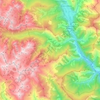
Name: Espot topographic map, elevation, terrain.
Location: Espot, Pallars Sobirà, Lerida, Catalonië, Spanje (42.50877 0.93720 42.61015 1.14621)
Average elevation: 1,867 m
Minimum elevation: 848 m
Maximum elevation: 2,926 m
De gemeente heeft een oppervlakte van 97 km² en telt 361 inwoners (1 januari 2016). De plaats ligt op een hoogte van ongeveer 1200 meter, aan de oostkant van het Nationaal park Aigüestortes i Estany de Sant Maurici.
Other topographic maps
Click on a map to view its topography, its elevation and its terrain.
Vilamur
Spanje > Catalonië > Pallars Sobirà > Soriguera
Vilamur, Soriguera, Pallars Sobirà, Lerida, Catalonië, 25566, Spanje
Average elevation: 1,276 m
Dorve
Spanje > Catalonië > Pallars Sobirà
Dorve, La Guingueta d'Àneu, Pallars Sobirà, Lerida, Catalonië, 25597, Spanje
Average elevation: 1,361 m