
Canto topographic map
Interactive map
Click on the map to display elevation.
About this map
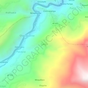
Name: Canto topographic map, elevation, terrain.
Location: Canto, Soraya, Aymaraes, Apurímac, Peru (-14.16589 -73.31511 -14.12589 -73.27511)
Average elevation: 3,045 m
Minimum elevation: 2,530 m
Maximum elevation: 3,973 m
Other topographic maps
Click on a map to view its topography, its elevation and its terrain.
Casinchihua
Casinchihua, Chacoche, Abancay, Apurímac, Peru
Average elevation: 2,399 m
Villa El Salvador
Peru > Apurímac > Villa El Salvador
Villa El Salvador, Chincheros, Apurímac, Peru
Average elevation: 3,644 m