
Make a donation
Hamilton topographic map
Click on the map to display elevation.
Make a donation
Hamilton
According to the United States Census Bureau, the town has a total area of 14.9 square miles (38.6 km2), of which 14.2 square miles (36.7 km2) is land and 0.73 square miles (1.9 km2), or 4.89%, is water. Hamilton lies 5 miles (8 km) inland from Massachusetts Bay, and both the eastern and western portion of town are bordered by water, with the Ipswich River to the west and Chebacco Lake and several other small ponds to the east. The highest point in town is found on Blueberry Hill in Bradley Palmer State Park, with an elevation of at least 215 feet (66 m), according to the most recent (2011-2012) USGS 7.5-minute topographical map. Several areas of town are protected, including Myopia Hunt Club and parts of Bradley Palmer State Park, Appleton Farm Grass Rides, and the Ipswich River Wildlife Sanctuary.
Make a donation
About this map
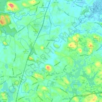
Name: Hamilton topographic map, elevation, terrain.
Location: Hamilton, Essex County, Massachusetts, United States (42.59341 -70.91991 42.66029 -70.80083)
Average elevation: 19 m
Minimum elevation: -2 m
Maximum elevation: 82 m
Make a donation
Other topographic maps
Click on a map to view its topography, its elevation and its terrain.
Make a donation
Make a donation
Little River Marshes
United States > Massachusetts > Essex County > Gloucester > West Gloucester
Average elevation: 27 m
Freshwater Cove Village
United States > Massachusetts > Essex County > Gloucester
Average elevation: 18 m
Blackwater River
United States > Massachusetts > Essex County > Salisbury > Salisbury Beach
Average elevation: 4 m
Make a donation
Make a donation
Make a donation
Make a donation
Make a donation
Make a donation
Make a donation
Make a donation
Kettle Cove Village
United States > Massachusetts > Essex County > Manchester-by-the-Sea
Average elevation: 18 m
Make a donation
Make a donation
Make a donation
Make a donation
Make a donation
Amesbury
United States > Massachusetts > Essex County > Amesbury
Amesbury is located at 42°51′29″N 70°55′50″W / 42.85806°N 70.93056°W / 42.85806; -70.93056. According to the United States Census Bureau, the city has a total area of 13.7 square miles (35.5 km2), of which 12.3 square miles (31.8 km2) is land and 1.5 square miles (3.8 km2), or 10.65%, is…
Average elevation: 24 m
East Parish
United States > Massachusetts > Essex County > Boxford > Boxford > East Parish
Average elevation: 38 m
Make a donation