
Thank you for supporting this site ❤️
Make a donation
Make a donation
Bayside Council topographic map
Click on the map to display elevation.
Thank you for supporting this site ❤️
Make a donation
Make a donation
About this map
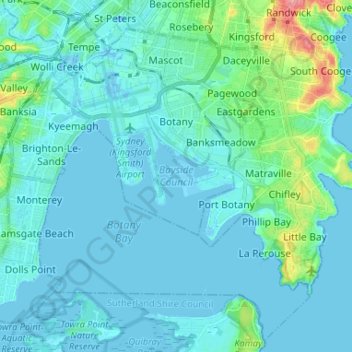
Name: Bayside Council topographic map, elevation, terrain.
Location: Bayside Council, New South Wales, Australia (-34.01012 151.10078 -33.91926 151.23162)
Average elevation: 11 m
Minimum elevation: -8 m
Maximum elevation: 83 m
Thank you for supporting this site ❤️
Make a donation
Make a donation
Other topographic maps
Click on a map to view its topography, its elevation and its terrain.