
Make a donation
Hernando County topographic map
Click on the map to display elevation.
Make a donation
Hernando County
According to the U.S. Census Bureau, the county has a total area of 589 square miles (1,530 km2), of which 473 square miles (1,230 km2) is land and 116 square miles (300 km2) (19.8%) is water.[9] According to the World Atlas USA, Hernando County is the geographic center of Florida. Elevation in the county ranges from mean sea level along the Gulf coast to its highest natural point of 269 feet at Chinsegut Hill.[10]
Make a donation
About this map
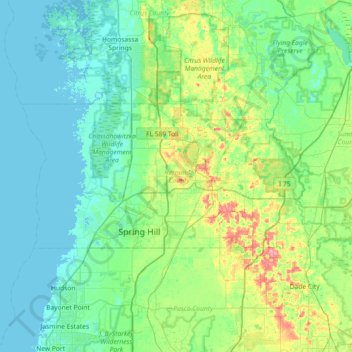
Name: Hernando County topographic map, elevation, terrain.
Location: Hernando County, Florida, United States (28.43329 -82.77844 28.69486 -82.05447)
Average elevation: 18 m
Minimum elevation: -1 m
Maximum elevation: 92 m
Make a donation
Other topographic maps
Click on a map to view its topography, its elevation and its terrain.
Wesley Chapel
United States > Florida > Pasco County
According to the United States Census Bureau, the CDP has a total area of 6.1 square miles (16 km2), of which 6.1 square miles (16 km2) is land and 0.04 square miles (0.10 km2) (0.49%) is water. The elevation is about 100 feet (30 m), combined with an inland location, creates more temperature variation in the…
Average elevation: 19 m
Make a donation
Miami
United States > Florida > Miami-Dade County
Miami and its suburbs are located on a broad plain between the Everglades to the west and Biscayne Bay to the east, which extends from Lake Okeechobee southward to Florida Bay. The elevation of the area averages at around 6 ft (1.8 m)[39] above sea level in most neighborhoods, especially near the coast. The…
Average elevation: 4 m
Make a donation