
Thank you for supporting this site ❤️
Make a donation
Make a donation
Tarakan Island topographic map
Click on the map to display elevation.
Thank you for supporting this site ❤️
Make a donation
Make a donation
About this map
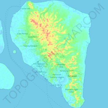
Name: Tarakan Island topographic map, elevation, terrain.
Location: Tarakan Island, Tarakan, North Kalimantan, 77112, Indonesia (3.23952 117.51449 3.44343 117.66909)
Average elevation: 11 m
Minimum elevation: -2 m
Maximum elevation: 102 m
Thank you for supporting this site ❤️
Make a donation
Make a donation